Water Supply
There is not one water supply for all of Hays County. Residents get their water from multiple sources.
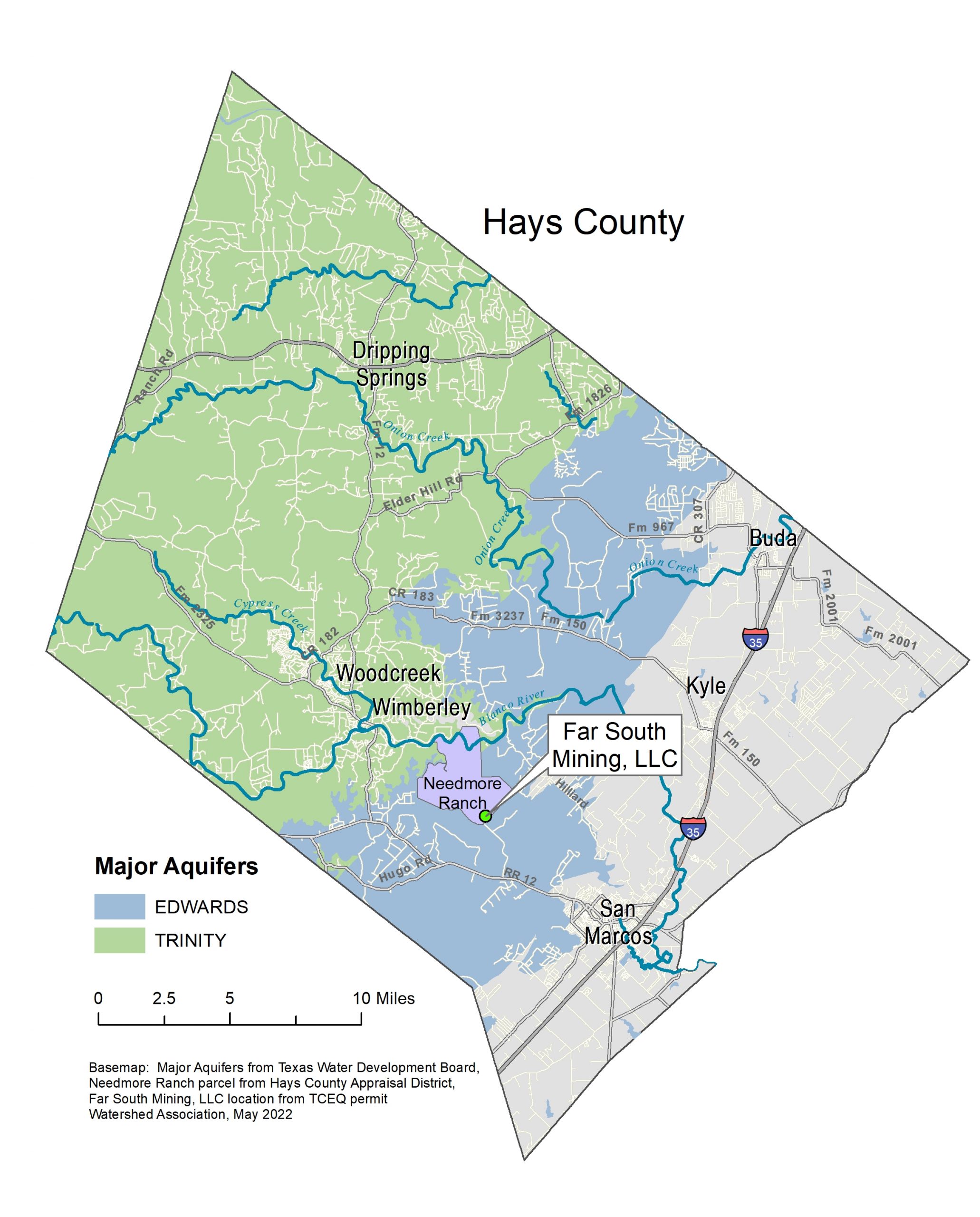
There are two aquifers that cover three fourths of Hays County. All residents get some of their water from the aquifers. Rural residents get all their water from wells drilled into either the Trinity or Edwards Aquifer.
The city of San Marcos gets approximately 75% of its drinking water from Canyon Lake and 25% from five separate water wells.
Dripping Springs has four water wells and gets additional surface water from the LCRA.
Kyle receives approximately 54% of its water from Canyon Lake. An additional 15% comes from five wells into the Edwards Aquifer. 19% comes from Alliance Regional Water Authority and the remaining 12% from the City of San Marcos.
Buda receives 70% of its water from Canyon Lake and 30% from the Edwards Aquifer.
The Edwards Aquifer
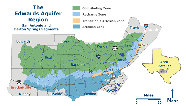
The Edwards Aquifer contains an underground layer of porous, honeycombed, water-bearing rock. The aquifer stretches from Austin in Travis County south to Bracketville in Kinney County. The Aquifer is divided into three main zones: the contributing zone, the recharge zone, and the transition/artesian zone.
The contributing zone occurs on the Edwards Plateau, also called the Texas Hill Country and is about 5,400 square miles. The contributing zone is also called the drainage area or the catchment area. Here the land surface “catches” water from rainfall that averages about 30″ per year, and water runs off into streams that flow over relatively impermeable limestone rocks until they reach the recharge zone.
The recharge zone is a 1,250 square mile area where highly faulted and fractured Edwards limestones outcrop at the land surface, allowing large quantities of water to flow into the Aquifer. Sinkholes can quickly receive large volumes of recharge during rainstorms and transmit the recharge directly into the Aquifer. Most recharge occurs in streambeds, entering the Aquifer through sinkholes or fault planes, but about 25% occurs wherever the Edwards limestone outcrops at the surface.
The transition zone is a thin strip of land south and southeast of the recharge zone from San Antonio to Austin where limestones that overlie the Edwards are faulted and fractured and have caves and sinkholes, so it is possible that surface water can still go into the Edwards limestone below. There are plenty of good wells and numerous springs in the transition zone, so it is actually also part of the artesian zone, which is the area where we can pump good water out through wells or it comes to the surface on its own through springs.
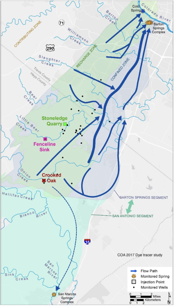
We can’t see the water in the aquifers, but it has a flow similar to rivers. In order to determine the flow, there are dye tracing studies that are performed. The City of Austin Watershed Department did a dye trace study in 2017 from the three locations located on the map to the right. Water in and north of Onion Creek flows north to Barton Spring in Austin. Water south of Onion Creek flows towards San Antonio. Because of these two different flow directions, the aquifer is divided into segments. The northern flow is called the Barton Springs segment and the southern flow is called the San Antonio segment. Dye injected at Stoneledge Quarry reached the main Barton Spring in just five days!
Understanding the underground flow is important to understanding the importance of being good stewards of the land. Any runoff with pollutants could have devastating impacts on our natural water, creeks, rivers, and springs.
Hays County is home to many water features that make it special. Flowing from the Edwards Aquifer and forming Spring Lake, the 200 San Marcos springs are the second largest group of springs in Texas. The springs feed the San Marcos River, which merges with the Blanco River and flows southward for 75 miles before joining the Guadalupe River. People have always been drawn to the freshwater springs along the Balcones Escarpment with their year-round temperature of 72 degrees, and artifacts have been found in the region dating back 19,000 years.
Another popular swimming spot is Jacob’s Well, which flows from the Trinity Aquifer outside of Wimberley. This spring has had flow problems due to over-pumping from neighboring wells in Woodcreek.